Thompson Ridge Trail
Hard · Out-and-back · 9 mi round trip · 1,619 ft gain · 3¼–4¾ hr
Ridge or pass
Parkingnot reported today
A full day with sustained climbing; bring plenty of water.
No hiker reports in the last 3 days. Be the first to report here
At this trail
Dogs allowed No fee or pass
Pack it out.
PermitsDay hikes: none. Overnight: wilderness permit.
AreaColville National Forest ›
Newport-Sullivan Lake, Three Rivers, Republic and Tonasket ranger districts U.S. Forest Service
Newport-Sullivan Lake, Three Rivers, Republic and Tonasket ranger districts U.S. Forest Service
Officialconditions › · roads › · fees › · permits ›
Rules, passes and closures change. Check the official Forest Service site before you go.
Getting there
Starts at Thompson Ridge Trailhead
Navigate to the trailhead: Google Maps · Apple Maps · coordinates 48.74618, -118.22464
Right now
⚠ Special Weather Statement until Sun 1:45 PMSpecial Weather Statement issued November 22 at 10:44AM PST by NWS Spokane WA
TodayAM26°93%
TonightPM25°41%
MonAM31°16%
MonPM26°1%
TueAM32°32%
TuePM30°51%
WedAM34°23%
WedPM32°93%
Light Snow, wind 1 mph · Full forecast ›
Daylight7:12 am 4:05 pm
Air qualityAQI 39 Good
Snow0″ snow at Sentinel Butte (4,680 ft, 18.1 km away)
Typical year: snowpack 15% of normal for the date · usually melted out by about May 7 · typical peak Apr 4
Typical year: snowpack 15% of normal for the date · usually melted out by about May 7 · typical peak Apr 4
Snow levelabout 1,000 ft now · 1,000–3,700 ft over the next three days · 0.5″ of new snow forecast in 48 h
PassSherman Pass SR 20 24 km
Eastbound: No restrictions · Westbound: No restrictions · No current road condition information available · 20°F · pass report ›
Eastbound: No restrictions · Westbound: No restrictions · No current road condition information available · 20°F · pass report ›
Cameras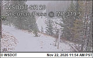
SR 20 at MP 319.5: Sherman Pass · 24 km › 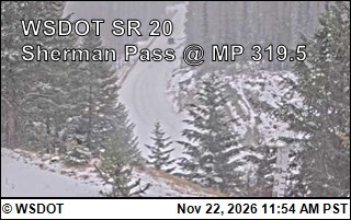
SR 20 at MP 319.5: Sherman Pass · 24 km ›
No reports in the last 3 days.
All conditions and reports at Thompson Ridge Trailhead
Something wrong on this page? Suggest a correction.