Tinkham Discovery Trail
Easy · Out-and-back · 0.6 mi round trip · 10–15 min
Parkingnot reported today
Good for families, first hikes and short outings. No bikes.
No hiker reports in the last 3 days. Be the first to report here
At this trail
Dogs allowed No bikes Northwest Forest Pass
Pack it out.
Official pageForest Service › record checked 2026-10-06
FeeView Recreation.gov for Fee Information
Noteopen 5/27 to 09/13
PermitsDay hikes: none. Overnight: wilderness permit.
AreaSnoqualmie Ranger District ›
I-90, Middle Fork and Highway 410, Mt. Baker-Snoqualmie National Forest U.S. Forest Service
I-90, Middle Fork and Highway 410, Mt. Baker-Snoqualmie National Forest U.S. Forest Service
Officialconditions › · roads › · fees ›
Rules, passes and closures change. Check the official Forest Service site before you go.
Getting there
Starts at Tinkham Discovery Trailhead
Navigate to the trailhead: Google Maps · Apple Maps · coordinates 47.40154, -121.56492
Right now
TodayAM43°20%
TonightPM31°39%
MonAM42°74%
MonPM34°70%
TueAM43°80%
TuePM35°80%
WedAM47°63%
WedPM37°97%
Slight Chance Light Snow, wind 2 to 6 mph · Full forecast ›
Daylight7:20 am 4:23 pm
Air qualityAQI 16 Good
WildfireThree Queens fire, 23 km away, 9,575 acres, 95% contained
Snow1″ snow at Mount Gardner (2,930 ft, 4.9 km away)
Typical year: snowpack 0% of normal for the date · usually melted out by about May 4 · typical peak Mar 16
Typical year: snowpack 0% of normal for the date · usually melted out by about May 4 · typical peak Mar 16
Snow levelabout 2,000 ft now · 2,000–5,200 ft over the next three days · 1″ of new snow forecast in 48 h
PassSnoqualmie Pass I-90 12 km
Eastbound: No restrictions · Westbound: No restrictions · Bare and dry, wet in places · 31°F · pass report ›
Eastbound: No restrictions · Westbound: No restrictions · Bare and dry, wet in places · 31°F · pass report ›
Cameras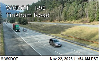
I-90 at MP 45.2: Tinkham Road · 3 km › 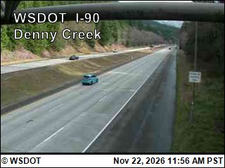
I-90 at MP 46.8: Denny Creek · 5 km ›
No reports in the last 3 days.
All conditions and reports at Tinkham Discovery Trailhead
Something wrong on this page? Suggest a correction.