Sisi Fire Trails ClosureTrail Closures are as follows and only apply to Forest Service lands:Pacific Crest Trail 2000 (PCT) – Closure begins where Forest Service Trail (FST) 2000 enters the Chelan Ranger District (CRD) at T. 32 N., R. 14 E.,…Forest Service · Aug 22 · details ›
ℹ Norse Peak and Clearwater Wilderness Use Restrictions on the Naches Ranger DistrictCamping is prohibited within 100 feet slope distance from the shoreline of any lake and/or the Pacific Crest National Scenic Trail EXCEPT at Echo Lake and Lost Lake within Norse Peak Wilderness.Forest Service · May 8 · details ›
ℹ Pacific Crest Trail Bicycle Restrictions - Forestwide or multi districtPursuant to 36 CFR 261.50 (a) . (b), the following is prohibited in or on any portion of tbe Pacific Crest National Scenic trail under Forest Service jurisdiction: Using or possessing a bicycle except by special-use…Forest Service · Aug 31 · details ›
⚠ SR 410 Chinook Pass is closed for the season due to adverse conditions and avalanche risk. Eastbound closure is at milepost 57 Crystal Mountain Boulevard, 12 miWSDOT · 8 km · Nov 21 · details ›
Snow1″ snow at Cayuse Pass (5,260 ft, 1.4 km away) Typical year: snowpack 15% of normal for the date · usually melted out by about Jun 28 · typical peak Apr 19
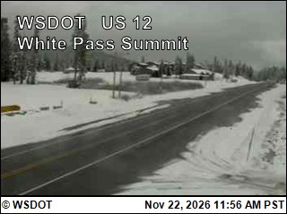
Snow levelabout 2,100 ft now · 1,900–4,900 ft over the next three days · 3.5″ of new snow forecast in 48 h
Winter roadChinook Pass (SR 410) and Cayuse Pass (SR 123) close each winter: SR 410 from Crystal Mountain Boulevard to Morse Creek, and SR 123 south to Stevens Canyon Road. Usually from November (October 24 in 2025) to late May. WSDOT ›
PassChinook Pass SR 4100 km Eastbound: Closed for the season · Westbound: Closed for the season · SR 410 Chinook Pass is closed for the season due to adverse conditions and avalanche risk. Eastbound closure is at milepost 57, Crystal Mountain Boulevard, 12 miles west of the summit. Westbound closure is at milepost 74.5, Morse Creek, 5 miles east of the summit. · pass report ›