Monastery Fire Trail
Easy · Out-and-back · 1.2 mi round trip · 144 ft gain · 25–35 min
Parkingnot reported today
Good for families, first hikes and short outings.
No hiker reports in the last 3 days. Be the first to report here
At this trail
Getting there
Starts at Brooks Memorial State Park Trailhead · 3 other trails start here
Navigate to the trailhead: Google Maps · Apple Maps · coordinates 45.94976, -120.66560
Right now
Burn Ban Level 2Wood fires restricted to fire pits in designated areas. Gas and propane allowed. Charcoal may be restricted.Washington State Parks · Sep 28 · details ›
⚠ Freeze Warning until Tue 9:00 AMFreeze Warning issued October 12 at 10:27AM PDT until October 13 at 9:00AM PDT by NWS Pendleton OR
TonightPM36°1%
TodayAM54°1%
MonPM38°
TueAM58°
TuePM43°
WedAM63°1%
WedPM46°
ThuAM62°
Mostly Clear, wind 2 mph · Full forecast ›
Daylight7:16 am 6:20 pm
Air qualityAQI 8 Good
WildfireSignal Peak fire, 46 km away, 3,000 acres, 100% contained
Snow0″ snow at Satus Pass (3,960 ft, 4.3 km away)
Snow levelabout 4,000 ft now · 3,700–9,300 ft over the next three days
PassSatus Pass US 97 4 km
Eastbound: No restrictions · Westbound: No restrictions · Bare and dry · 31°F · pass report ›
Eastbound: No restrictions · Westbound: No restrictions · Bare and dry · 31°F · pass report ›
Cameras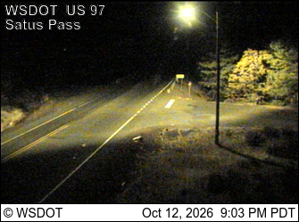
US 97 at MP 27.1: Satus Pass · 4 km › 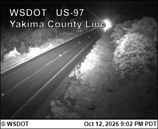
US 97 at MP 34.5: Yakima County Line · 12 km ›
No reports in the last 3 days.
All conditions and reports at Brooks Memorial State Park Trailhead
Something wrong on this page? Suggest a correction.