⚠ Part of the Park is ClosedThe trestle at Revere is temporary closed for repairs. Revere Road can be utilized as a detour.Washington State Parks · Jul 2 · details ›
Burn Ban No fires at any timeNo fires permitted at any time.Washington State Parks · Jun 9 · details ›
ℹ NotificationThe Snoqualmie Tunnel will be closing for the winter season at dusk on Oct 31st, 2026. It is scheduled to reopen in May depending on snow/ice conditions.Washington State Parks · Oct 30 · details ›
ℹ ConstructionConstruction will occur on the Palouse to Cascades State Park Trail beginning at the intersection with Hole-In-The-Ground Rd. heading West for 3.5 miles. This work is set to start December 2026 and end June 2027. The…Washington State Parks · Oct 14 · details ›
TodayAM33°17%
TonightPM27°39%
MonAM33°39%
MonPM26°31%
TueAM34°54%
TuePM29°54%
WedAM37°38%
WedPM31°65%
Areas Of Freezing Fog then Areas Of Fog, wind 2 mph · Full forecast ›
Daylight7:14 am4:20 pm
Snow levelabout 1,700 ft now · 1,400–3,800 ft over the next three days · 0.5″ of new snow forecast in 48 h
PassManastash Ridge I-8212 km Eastbound: No restrictions · Westbound: No restrictions · Bare and wet with slush in places. · 32°F · pass report ›
Cameras
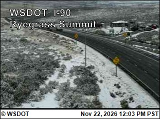
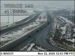
I-90 at MP 125.8: Ryegrass Summit · 7 km ›I-90 at MP 115.4: Kittitas · 9 km ›
No reports in the last 3 days.
Trail updates are public. The summary uses the last 6 hours (trail state the last 3 days); older reports stay in the history so seasons can be compared. Times are Pacific. Something wrong on this page? Suggest a correction.