Snow0″ snow at Mowich (3,170 ft, 20.6 km away) Typical year: usually melted out by about Mar 16 · typical peak Feb 25
Snow levelabout 2,400 ft now · 2,400–5,700 ft over the next three days
PassCayuse Pass SR 12345 km Eastbound: Closed for the season · Westbound: Closed for the season · SR 123 Cayuse Pass is closed for the season. For outdoor recreational information visit the Mount Rainier National Park road status page: https://www.nps.gov/mora/planyourvisit/road-status.htm · 36°F · pass report ›
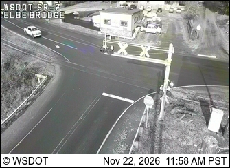
Cameras
SR 7 at MP 16.7: Elbe Bridge · 6 km ›SR 7 at MP 1.2: North Morton · 26 km ›
No reports in the last 3 days.
Trail updates are public. The summary uses the last 6 hours (trail state the last 3 days); older reports stay in the history so seasons can be compared. Times are Pacific. Something wrong on this page? Suggest a correction.