Burn Ban Level 2Wood fires restricted to fire pits in designated areas. Gas and propane allowed. Charcoal may be restricted.Washington State Parks · Sep 25 · details ›
ℹ GeneralPearrygin Lake State Park will close for camping for the season starting 10/30/2026. All campers must exit the park by 1pm on 10/30/2026. A portable toilet will be available 11/01/2026 in the East boat launch for day…Washington State Parks · Oct 2 · details ›
Snow levelabout 1,800 ft now · 1,200–3,600 ft over the next three days · 0.5″ of new snow forecast in 48 h
PassLoup Loup Pass SR 2024 km Eastbound: No restrictions · Westbound: No restrictions · Compact snow and ice. · 29°F · pass report ›
Cameras
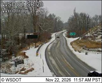
SR 20 at MP 192.5: Winthrop - Rader Rd · 2 km ›Methow Valley State Airport Northwest · 8 km ›
No reports in the last 3 days.
Trail updates are public. The summary uses the last 6 hours (trail state the last 3 days); older reports stay in the history so seasons can be compared. Times are Pacific. Something wrong on this page? Suggest a correction.