⚠ Closed: Miners Fire closure (Darrington Ranger District, order 06-05-26-17, in effect until rescinded): Suiattle Road Forest Service Road 2600, the Suiattle and Downey Creek trailheads, Sulphur Creek Campground and the Suiattle River, Downey Creek, Sulphur Creek, Sulphur Mountain, Miners Ridge, Image Lake, Buck Creek Pass, Milk Creek and other trails in the area, plus the Pacific Crest Trail from Mica Lake to Suiattle Pass. official status(checked 2026-10-05)
⚠ Road closed: Suiattle River Road (Forest Service Road 26) is closed to vehicles at milepost 4 after the February 2026 flood, with its spur roads, through January 1, 2028 (order 06-05-26-03). The Suiattle River, Sulphur Creek and Downey Creek trailheads are a long road walk away, and the Miners Fire closure still covers the trails beyond them. official status(checked 2026-10-05)
Chance Light Rain then Mostly Cloudy, wind 2 to 6 mph · Full forecast ›
Daylight7:21 am4:30 pm
Air qualityAQI 13 Good
Snow levelabout 2,400 ft now · 2,400–5,700 ft over the next three days
Cameras
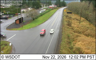
US 12 at MP 97.2: West Morton · 10 km ›SR 7 at MP 0: Morton · 10 km ›
No reports in the last 3 days.
Trail updates are public. The summary uses the last 6 hours (trail state the last 3 days); older reports stay in the history so seasons can be compared. Times are Pacific. Something wrong on this page? Suggest a correction.