← All trailheads · Methow Valley
Town Trailhead
1 trail starts here · Methow Valley
Parkingnot reported today
No hiker reports in the last 3 days. Be the first to report here
Open in the app (live map, alerts, offline maps)
At this trailhead
Dogs on leash No fee or pass
Pack it out.
Getting there
Navigate to: Google Maps · Apple Maps · coordinates 48.47295, -120.18062
Trails from this trailhead
- Methow Community Trail · Out-and-back · 19.1 mi one way · 552 ft gain · 11¼–15¾ hr · Strenuous
Right now
TodayAM36°53%
TonightPM29°56%
MonAM37°56%
MonPM22°35%
TueAM34°84%
TuePM25°84%
WedAM40°39%
WedPM31°95%
Chance Rain And Snow, wind 1 mph · Full forecast ›
Daylight7:19 am 4:14 pm
Air qualityAQI 67 Moderate
WildfireSisi fire, 50 km away, 4,816 acres, 90% contained
Snow0″ snow at Muckamuck (4,470 ft, 26.3 km away)
Snow levelabout 1,800 ft now · 1,200–3,500 ft over the next three days · 0.5″ of new snow forecast in 48 h
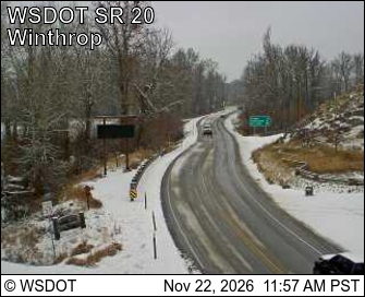
PassLoup Loup Pass SR 20 23 km
Eastbound: No restrictions · Westbound: No restrictions · Compact snow and ice. · 29°F · pass report ›
No reports in the last 3 days.
Trail updates are public. The summary uses the last 6 hours (trail state the last 3 days); older reports stay in the history so seasons can be compared. Times are Pacific. Something wrong on this page? Suggest a correction.