Rules, passes and closures change. Check the official Forest Service site before you go.
Getting there
⚠ Road closed: Storm-damaged roads order (06-17-04-26-18, through December 1, 2026): no motor vehicles on Forest Service Road 4430 (West Twisp River) between the War Creek and Williams Creek spurs, Forest Service Road 4300-100 (War Creek), 4435 (Reynolds), 4415 (Little Bridge Creek) and 4400-100 (Lime Creek). War Creek, Williams and Reynolds Creek trailheads are reached on foot. official status(checked 2026-10-06)
WildfireSisi fire, 27 km away, 4,816 acres, 90% contained
Snow1″ snow at Rainy Pass (4,880 ft, 23.8 km away) Typical year: snowpack 9% of normal for the date · usually melted out by about Jun 21 · typical peak Apr 18
Snow levelabout 2,000 ft now · 1,300–3,900 ft over the next three days · 2.5″ of new snow forecast in 48 h
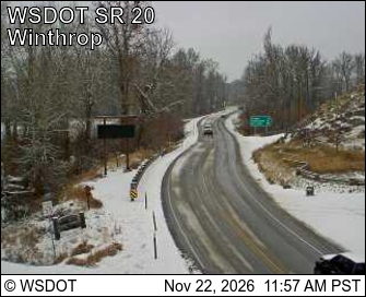
PassNorth Cascade Hwy SR 2021 km Eastbound: No restrictions · Westbound: No restrictions · Compact snow and ice · 28°F · pass report ›
Cameras
SR 20 at MP 192.5: Winthrop - Rader Rd · 22 km ›Methow Valley State Airport Northwest · 24 km ›
No reports in the last 3 days.
Trail updates are public. The summary uses the last 6 hours (trail state the last 3 days); older reports stay in the history so seasons can be compared. Times are Pacific. Something wrong on this page? Suggest a correction.