Washington Trail Conditions

← All trailheads · Okanogan

Muckamuck Trailhead

1 trail starts here · Okanogan

EF
Parkingnot reported today

No hiker reports in the last 3 days. Be the first to report here

Open in the app (live map, alerts, offline maps)

At this trailhead

Pack it out.

Official pageForest Service › record checked 2026-10-06
PermitsDay hikes: none. Overnight: wilderness permit.
AreaColville National Forest ›
Newport-Sullivan Lake, Three Rivers, Republic and Tonasket ranger districts U.S. Forest Service

Rules, passes and closures change. Check the official Forest Service site before you go.

Getting there

Navigate to: Google Maps · Apple Maps · coordinates 48.62118, -119.84646

Trails from this trailhead

Right now

Post an update here

TonightPM35°4%
TueAM49°4%
TuePM38°9%
WedAM55°9%
WedPM40° 
ThuAM54° 
ThuPM42° 
FriAM55° 

Mostly Cloudy, wind 1 mph · Full forecast ›

Daylight7:16 am 6:14 pm
Air qualityAQI 13 Good
WildfireSinlahekin fire, 15 km away, 166,007 acres, 99% contained
Snow28″ snow at Salmon Meadows (4,460 ft, 3.8 km away)
Snow levelabout 4,400 ft now · 4,400–8,800 ft over the next three days
PassLoup Loup Pass SR 20 26 km
Eastbound: No current information available · Westbound: No current information available · 36°F · pass report ›
Cameras
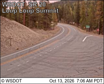
SR 20 at MP 214.5: Loup Loup (Looking East)
SR 20 at MP 214.5: Loup Loup (Looking East) · 26 km ›
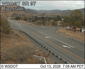
US 97 at MP 299: Riverside
US 97 at MP 299: Riverside · 28 km ›

No reports in the last 3 days.

Reports are anonymous. The summary uses the last 6 hours (trail state the last 3 days); older reports stay in the history so seasons can be compared. Times are Pacific. Something wrong on this page? Suggest a correction.